A Call to Trails on Delmarva


A few nights ago I was asked by a friend where she could hike on Delmarva with her family and if there was a website that explained a little about the trails. I started to think and realized that there wasn’t really a “go to” page for running trails around The Greater Salisbury area. I know at this time there are not a lot of trail runners on Delmarva, but that is changing quickly and I hope this blog encourages more people to get out and experience the outdoors especially the trails. I will break this up into two sections: actual, existing trails and potential (hopefully future) trails. I will include websites to the parks, where available, and give my opinion and experience on the trails. Enjoy. 

1. Pemberton

Pemberton Trails

These are the first trails I ever had the pleasure to run on and are also the closest to where my running group meets for training runs. It consists of over 4.5 miles of trails and is just minutes from downtown Salisbury. It is open from sunrise to sunset. The trails are for the most part wide and nontechnical (meaning not many rocks or roots) and parts are covered in soft mulch lending itself to comfortable running conditionals. It does get quite muddy after large rainfalls. It is very beautiful to experience during a sunrise over the Wicomico River and during the fall with the changing of the leaves. Beware of ticks and biting flies during the summer and be mindful of your footing when crossing the foot bridges. It is a great place for families since there are bathrooms and the trails are well marked. It is also a very cool historical site to visit. 

2. The Zoo Trails

How difficult could it be to find a map of the trail right next to The Salisbury Zoo? Obliviously pretty difficult considering I just spend 20 minutes trying to do so. Park at the zoo on the east side and cross the street to the other side parking lot going toward the dog park and that is where you will begin to find the zoo trails. If you only run the zoo side you can get in two miles around the trails. These trails are a lot of fun and will give you the closest thing we can come to when it comes to hills. It is newly marked (Thanks to the mountain biking club in town) and easy to follow. I wouldn’t recommend running this area alone in the dark since it could potentially be dangerous due to roots and the occasional stranger. It more technical than Pemberton and more difficult due to the twists and turns of the trails. If you find a good map of the trails send me the link. 

3. Trap Pond

Trap Pond

Our neighbors to the north in Laurel, Delaware have quite the gem in Trap Pond. Although it is a good twenty to thirty minute drive up to the park, this trail is fast and very safe. The trail is wide and the views of the lake and trails are breathtaking. There are often other hikers, runners and bikers on the trails so be cautious. If you want a real fun adventure try running the horse trails. There is a camp store that sells snacks and Gatorade and in the spring there is an ultra marathon that runs the loop around the park like six times. This is the perfect park to bring the family out of a picnic and a bike ride around the pond. The pond loop is a little over four miles and I was able to do it with my two young sons. 

4. Naylor Mill Trails 

Naylor Mill Trails
Be prepared to get lost. These trails are not marked at all, which I find very appealing. It is fun to get lost. I had to run these trail at least a handful of times before I began to get a feel for where everything connected. The entire system of trails is over five miles long. These are some real singletrack trails. The are some rolling hills and fun mountain biking obstacles to run over or around. The trail is as close to nature as you can get in my opinion in the Salisbury area. It is quiet and secluded in the mornings. On the weekends there are more people since it borders witha number of soccer and baseball fields. For trail running it is the best location in Salisbury due to its beauty, difficulty, and location. There is a big parking lot to use to park in or to do speed work. Be cautious of ticks, chiggers, and bugs in the summer. Also if it is during the daylight be cautious of mountain bikers (This is their baby). We need more locations like Naylor Mill that are free of trail markers and signage and full of amazing trees and trails.  

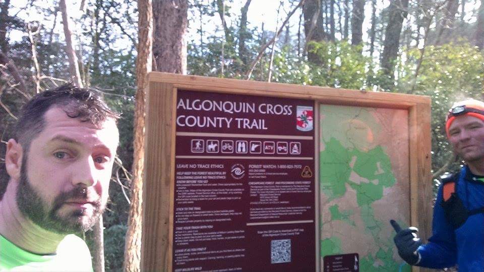
5. Algonquin Cross Country Trail 

Algonquin Cross Country Trail 

This is fabulous 12.5 mile trail from Snow Hill road to Pocomoke is quick, when not flooded, trail that winds through woods, fields, and roads. It is well marked with makers every 1/10 of a mile. I wrote an entire piece on this last week so I won’t dwell on it, but it is definitely a trail I will revisit often. If you haven’t hiked or ran this trail, do it. 

6. Wicomico Demonstration Forest Trails

Wicomico Demonstration Forest Trails
These are flat and in the middle of nowhere in the forest off of sixty foot road in Parsonsburg. There are no hills, no twists, and no real turns. Wide, not singletracked, and built for horses and humans. Be careful holes in the trails from horseshoes. In the winter it is not unusual to see crosscountry ski tracks or even snowmobile tracks. There are at least six miles of trails in the eight different trials. The dark blue trail I three miles apart from the rest of the trails and I have yet to explore it. The trails are well marked and very safe for families and individuals running or hiking alone. There are maps available at the parking lot. The trails do tend to flood at times and in the summer avoid the long grass since they are full of chiggers. There are lots of fast country roads around theses trails if you want a fun hybrid run. 

———- Potential Trails———

1. Pirate’s Wharf

Pirate’s wharf is a piece of land that Wicomico county owns that would make for a perfect location to blaze trails through the woods and along the Wicomico River. I would love to see at least six miles of trails running through this property. Using this land for anything other than outdoor activities would be a travesty. Let’s push to encourage the county to use this land for trails that can be used for runners, bikers, and hikers. 

This video will tell you all about Pirate’s Wharf 

Pirate’s Wharf Video
2. The green corridor

I’d love to see a trail or greenway between Pemberton Park and Salisbury Park/Salisbury Zoo area

3. Ellis Bay Wildlife

I’d love to see trails running through The Ellis Bay Wildlife management area Nanticoke, Maryland. 

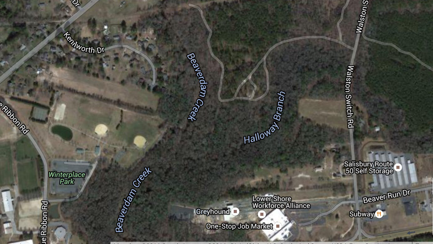
4. Winterplace Extension

There are currently two miles of trails at Winterplace, but frankly they aren’t worth writing about. There are not enough miles and the miles that are there are not spectacular in beauty of difficulty. There is land around Winterplace that could be used for more trails.  We could easily add eight miles of trails in the woods around Beaverdam Creek and Halloway Branch. This could easily be another Pemberton and I look forward to the day it is. 

 
We have beautify trails in this area of Delmarva and the opportunity for more. Let’s get out and enjoy the trails and promote making more of them for ourselves, our families, our friends and our visitors. 

Algonquin… We finally meet


The longest trail on Maryland’s Eastern Shore had eluded me for far too long. It knew it was there and it knew I was anxious to conquer it…. But we never met until this past weekend. The annoyance and potential dangers of ticks, chiggers and mosquitos kept me away during the summer, so when an available Saturday opened up this winter I knew it was game on. I didn’t just want to run the trail, I wanted to run the length of the trail and then run back to the start.

The night before, while watching “The Making of a Murderer”, I packed my Orange Mud hydration vest with three packets of GU, two mini bagels, energy chomps and two bottles filled with water and Tailwind. I was preparing and planning for a self-supported 25 mile run on the soft dirt trails. The trails are fairly new and are relatively unknown. They were created for hikers, bikers and horseback riders, but this weekend the trail runners of Delmarva would own it… Well sorta, when we weren’t lost.

When I arrived at the north trailhead at a little after 5:30 in the morning there were five cars and seven runners waiting for me (Yeah I was late, It took a few extra minutes to scrape the frost off my car). It was an amazing collection of runners including a few guys who had run 50 and 100 mile races. It was a chilly 23 degrees when we began and after two days of rain and snow I thought a colder day would freeze the trail and make for an easier run. I was wrong.

After a quick, dark selfie, thanks to Gabe’s long arms, we were off and running. The proper-speed-pecking order usually doesn’t happen in the first mile or two, so I was lucky to be up front talking with The Swift Brothers Brian and Mark… Who happen to both be quite swift. Really. The conversation was flowing and we were laughing at each other’s running stories. Well… until we began to realize we hadn’t seen a trail marker for a while. Oh boy.

The Algonquin trail is marked every tenth of a mile througout the 12.5 mile trail. You would think after not seeing a trail marker beyond the third one we would turn around after a few tenths of a mile. We ran another mile and a half before deciding to turn around. I have no one to blame but myself considering I was in the front of the pack at this point. We turned around and realized that after only covering 1/3 of a mile of the actual trail we had already added an extra three miles to our trip.

No one was upset. Most were pretty excited that instead of 25 miles we were now going to go beyond a marathon. I was worried more about the time than the distance and the worry would increase in the next few miles….

Mile 2 of the actual trail was covering in water. I mean completely covered. At this point I was behind the actual group with one guy behind me. When I saw the trail buried in water and the majority of the group tiptoeing around the pool of water, I decided it was of no use trying to stay dry.

I saw Gabe on the other side of the water and I plowed through. My feet were soaked to the bone with blistering cold water. As my feet crushed through the thin ice and sank the six or seven inches to the bottom they numbed up… but I kept moving. On the other side all I could think of was moving. Moving. Moving. I had to somehow warm up my Klondike feet. I looked down and saw my shoes were icing over from the water. My feet warmed up pretty quickly until we turned the corner and there was another impossible-to-get-around flooded portion of the trail. Icy cold… Tingling… Numbing… And so much FUN. An adventure. We kept going until about mile 3.5 of the actual trail (6.5ish total).


On a random road that crossed the trail was Jay waiting near his truck. We were 40+ minutes later than he expected, but I am sure he enjoyed waiting around at six in the morning in the middle of the woods. We took a group picture and ventured on….


Melissa was our only female runner and she lead the way with both her speed and her toughness… A  little further down the trail we see Jeff Smith blazing up the trail from the opposite end. He started at the south end at five a.m. and ran to meet us. He must have been clipping off miles at an insane pace because he showed up less than a mile after we met up with Jay. The entire group was together. All ten of us headed south.

The mud, snowy patches and pools of water slowed us down, but the stories and company kept us moving. After about 8 miles in Chris and I began to lose sight of the group. We couldn’t even see Jim’s shoes (Altras with their footprint-looking bottom soles). The other runners were all much faster and we would have exhausted ourselves trying to keep up with their pace. It probably didn’t help that Chris and I ran into this…


We had no clue which way to go. So we went straight and ended up at a road with no further direction or trail markers. We quickly turned around and headed down the “closed” area of the trail. A mile into the closed portion of the trail we realized why it was closed. More swamp running. A half a mile worth of it.

When the swamp ended the muddy road began and there were very few stable places to throw down your feet. Slippery and sloshy we pressed forward until we ran into…. a beautiful, winding single track trail! Wow. The energy level skyrocketed. We were depleted physically, but alive with excitement from the newly found trail.

Fueled by the glorious trails we checked off mile after mile. Mile seven, mile eight, mile nine and mile ten.

Wait. There is Jeff’s car, but where is Jeff? It was mile ten of the trail, but mile 13 or 14 of our adventure. Chris had to get home and the trip down took much longer than expected. There were two more miles south and we had to believe that Jeff and the others were at the end or returning north.

After a mile and a half on the southern most end of the trail we ran into Gabe, Brian, Mark, Melissa, Jay, Jeff and Jim as they headed back north. Jeff was heading back to his car and said he would pick up Chris at the end.

I was in a dilemma. Should I run the 12.5 miles back to the start and be extremely late getting home, go back with Chris or call my wife from the trail and see if an extra hour could be added to my adult recess time? I made the phone call.

Green light! I running back I thought! Solo! I thought. Wow.

Chris and I arrived at the end of the trail and I was able to fill my water bottles. We had time to snap a picture before Jeff arrived. I wanted to sleep, I wanted to rest, I wanted to eat, but more importantly…. I wanted to run the entire trail back to the beginning!


A quick goodbye to Chris and Jeff and I was off.

It was tough. I dug deep. I dug real deep. The puddles were not as exciting running alone and felt more like annoying obstacles than Adventurous challenges. I kept telling myself to just keep moving. I kept saying to just “embrace the suck”.

Ken Chlouber, a Colorado miner and creator of the Leadville Trail 100 mile race once said “Make friends with pain, and you will never be alone.” Pain is a mean friend. Pain and I hung out for a few more hours as I endured and relentlessly carried on. I had plenty of water, enough fuel, and warm gloves and hat, but my legs were hurting. They felt like they were covered in thick metal. Heavy and difficult to move. It was wasn’t thick metal. It was thick mud.

Suddenly, I passed a hunter who had a decoy set up in the middle of the trail. He was trying to hunt crow. I didnt help his cause and he didn’t help mine as I feared hunters the rest of my journey. My orange hat came in handy!

Mini goals moved me forward. Tiny little goals.

“Let me get to the next mile marker,” I’d tell myself or “let’s make it to the muddy road” or “let’s just run until there is another puddle and then I can rest”… But you never truly rest. You kinda lie to yourself. It works. Self deception is a wonderful thing. I lied to myself until three miles to go when I hit a root… a huge root… and I went flying.

I landed on my side on the trail and I suddenly cramped up. The entire left leg cramped up. Okay I screamed a little. Maybe a lot. My leg was shaking. I had to stretch it out and wiggle my toes. Within a minute the cramp was gone – A LONG MINUTE, but then suddenly I had the urge to take a nap. Yes. A nap.

I wanted to sleep on the muddy, cold, stinky trail with 27 miles logged and three to go. I wanted to just sleep. No one would have known. I could have slept for an hour and then woke up and finished the trail. The sleep would have been wonderful. I could have dreamed of delicious hot chocolate and German pancakes…. And a warm bed.

That was a foolish idea. I got up. Told my legs to basically shut up and finished the last three miles.

Not fast.

Not strong.

But I kept going. I didn’t come out to the trail to go on a hike or to fall asleep on the trail. I came out with some good friends to run The Algonquin Trail and that is what we did. In the end my watch showed 29.9 miles on the trail, but more importantly were the memories logged as we spent the morning reaching a goal.

When the trail ended there was no band at the finish line, no finishers’ medals, no ALQ 29.9 stickers, no bananas, no chocolate milk, no beer tents or picture booths…. In fact there was nothing and no one. Just me.

And a smile.